A gazetteer allows users to search for named locations (such as street names or town names) and zoom to that location in 1Plan.
You can configure a gazetteer from the 1Plan admin interface, within the Gazetteer page.
Note: To configure a gazetteer, you must configure a WFS containing a single featuretype with at least a geometry property and a name property.
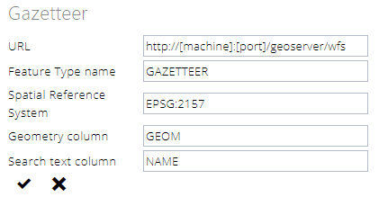
Gazetteer settings
Specify the following values:
-
URL - The URL of the map service, not including any parameters such as ?request=...
For example, if the following URL is used to retrieve the GetCapabilities document: https://www.mycompany.com/geoserver/wms?request=GetCapabilities then provide the URL https://www.mycompany.com/geoserver/wms.
For password protected URLs, the service must be configured so that the security credentials can be passed as part of this URL, for example: https://Username:Password@www.mycompany.com/WMS/services/MapServer/WMSServer
-
Feature Type name - The name of the feature type to query within this WFS.
To search for values within more than one table, either create a single gazetteer table from multiple source tables, or create a view that combines the rows from multiple tables and serve the view as a WFS featuretype.
-
Spatial Reference System - the projection must specify the coordinate reference system in which the data is stored.
This should be an OGC GML compliant srsName value that matches your data, such as EPSG:4326 or urn:ogc:def:crs:EPSG::2157.
-
Geometry column - The name of the geometry property on which to centre the map.
-
Search text column - A string property that is searched to find a list of potential names to show to the user.