
Errors in Spatial Data
When viewing geospatial data, it can often be easy for errors in graphical representation to be missed.
The left hand image is an example of data which looks connected. However, the image on the right shows a zoomed in image of the same intersection. The data is clearly not connected.
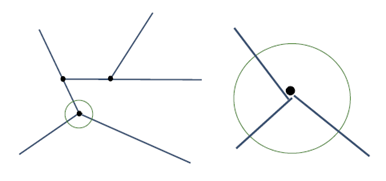
Data is seen to not be connected when zoomed in
Similarly, errors in logical representation can be easily missed.
In the example below, the subtype attribute for these two objects should be the same. Again, this type of error could easily be missed and could have costly consequences.
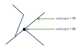
Data has different subtype attributes
Measuring and improving data quality, or combining and enhancing data into new forms, requires efficient and rigorous application of intelligent business rules. 1Integrate for ArcGIS greatly reduces the time taken to check for errors and provides a rigorous, efficient, and cost-effective mechanism to measure and maintain spatial data quality.

Copyright © 2019 1Spatial
US Patent Number 9542416 B2 (2017-01-10)

