Opening and Selecting Data
When defining a Session, you can select the data that you want to be opened.
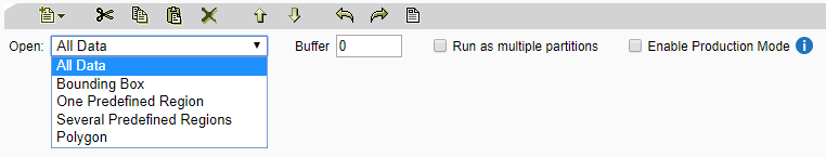
Open data options
A Buffer can be set to consider data in a region that is larger than the selection (see Scope and Buffer Regions). The buffer value is in dataset units.
The Run as multiple partitions option allows each region from several predefined regions to be run as independent sessions across the grid of engines (see Partitioning).
Enable Production Mode avoids saving the intermediate state of data between tasks. This saves disk space and improves performance, but disables the ability to rewind certain tasks and use the Session Data Viewer to visualise the session data. (See Production Mode.)
Note: The extent restriction defined here can be overridden at a task level using the Open Data Task. See Open Data Task for more.
All Data
By default, a session will be run on All Data. This means the session will apply to all data from all opened data sources (selected in Open Data tasks).
Bounding Box
The Bounding Box setting can be used to define a rectangular area of your data to be analysed. Processing will only apply to objects that lie partially or wholly within this region.
The co-ordinates of the area (MinX, MinY, MaxX, MaxY) are defined in dataset units.
One Predefined Region
You can define a single predefined region which is a polygon area of a dataset.
First select a Data Store to be opened, then define the following parameters:
- Table - a table name that corresponds to a class
- Where - a column name that corresponds to an attribute
-
equals - a value for the attribute
Note: You can optionally include a session parameter in the equals field. Any session parameter must be preceded by
$, e.g:$SessionParameter.
Several Predefined Regions
You can define multiple predefined areas that are multiple polygons in a dataset.
When a data store is opened, the classes where the predefined areas exist are selected according to the table name.
First select a Data Store to be opened, then use the Table parameter to enter a table name that corresponds to a class.
Polygon
Define a polygon extent as a Well Known Text (WKT) geometry, for example:
POLYGON ((30 10, 40 40, 20 40, 10 20, 30 10))
This must be in the same spatial reference system as the data.
Note: Multi polygons, polygons with holes, circles and polygons with arc segments are not supported.