1Spatial unveils new survey capabilities in 1Edit

Cambridge, UK, 20th January 2022, (www.1spatial.com) 1Spatial, the global geospatial software and solutions leader, have extended the capability of their survey application, 1Edit, with increased support for photos and 2.5D data.
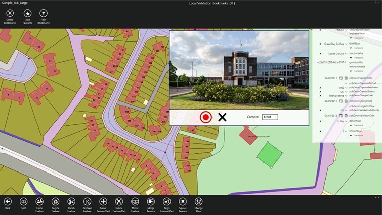
1Edit 3.1 allows users to attach feature photos, including automated geotagging, which enables surveyors to visualise assets and fine tune their observations. The latest version now includes new validation functions and improved handling for Heights (2.5D data), typically useful for detailed asset and land management surveys.
Enhanced styling, including bitmap fills and dashed lines make it easier to identify and classify different asset types during surveys. Additional control of editable layers and fields provide protection for non-editable data and protects the quality of data. Significant improvements to rendering of thematic mapping, further enhances the speed and fluidity of the intuitive user interface.
Seb Lessware, Chief Technical Officer at 1Spatial says:
"I'm delighted that 1Edit is making it easier and more effective for surveyors to collect accurate data in the field. Enhanced styling provides better visualisation of geospatial data for surveyors. Photos captured during the survey are visible in the field and in the office as a useful reference for inspectors who are hybrid working. Improved rendering speeds up surveys and map navigation.
Robert Chell, Chief Product Officer at 1Spatial commented:
“1Edit’s new survey capabilities further expands our customers’ ability to collect trusted, validated data that is right first time. By increasing the number of validation options available during a survey, we improve both the quality and accuracy of data, and the effectiveness of survey processes.
Through this and our ongoing product enhancements relating to 3D data, we are committed to providing dynamic market offerings that utilise our world leading data management capabilities, enabling our customers to unlock the value of their data.”
1Edit now supports the storage of photographs as an attribute on a feature. The photos can be captured from the front or rear camera and are stored as a Label object.
If you would like to find out more about 1Edit, and the rest of the 1Spatial Platform, please get in touch.