1Water
Product
An enterprise spatial data management system for water and wastewater networks
Designed in collaboration with our customers, 1Water provides out-of-the-box business apps that take advantage of years of operational utilities experience. Based entirely on Esri’s ArcGIS Utility Network extension, 1Water enables modelling, management and operation of your water and wastewater networks at a level of detail that has never before been possible.
Overview
1Water capitalises on 1Spatial's many years of experience working with utilities and major network operators to help them ensure the safe and reliable supply of their products to their customers, while ensuring regulatory compliance.
It is based on Esri's ArcGIS Enterprise architecture and uses the ArcGIS Utility Network (UN) model.
Leveraging these experiences, 1Water provides a collaborative Design, Manage, Operate environment that combines technical, geospatial, and operational data from multiple sources so that everyone has an accurate view of the network as it is operated.
The solution’s architecture removes timely reconfiguration of your business applications when upgrades of the underlying Esri technology are required. This makes the solution rapid to rollout, easy to manage and maintain, and quickly provides benefits to the operational business whilst reducing IT overheads.
1Water enables geographic data and asset management, as well as network modelling, editing and analysis. The solution allows you to model your entire utility network in ArcGIS at a new level of detail and performance.
- 1Water offers a full GIS solution, with ‘out of the box’ business applications for the water and wastewater utility.
- Based on Esri’s ArcGIS, 1Water provides a complete, reliable and efficient system to manage all data flows and business processes on the web, on mobile and for the office.
- 1Water is a collaborative tool which enables your teams and operators to access accurate data in real time.
- Through its pedigree, 1Spatial brings an expertise in GIS applied to the management of utility networks, with numerous projects across Europe and beyond.
1Water is a suite of professional software based on desktop, web and mobile interfaces of the ArcGIS Enterprise Suite from Esri.
- 1Water is integrated with the ArcGIS Enterprise platform, the leading GIS technology, offering powerful mapping, visualisation, analysis and data distribution functions.
- 1Water provides a complete geographic database model built on the Utility Network model and interacts closely with the ArcGIS platform, with authentication mechanisms using Portal for ArcGIS.
- The desktop client on ArcGIS PRO offers precise drawing and powerful editing tools combined with 1Water utilities functions.
- 1Water manages the workflows of different groups and types of users within comprehensive business interfaces that leverage the full web mapping, query and navigation powers of ArcGIS.
- It controls and manages the workflows of field editors who use ergonomic interfaces on Android to edit and view data.
1Water provides an architecture that allows for easy integration with other software applications used by water utilities for asset management such as job tracking systems, computerized maintenance management systems (CMMS), customer management systems (CRM) and hydraulic modelling systems (EPANET).
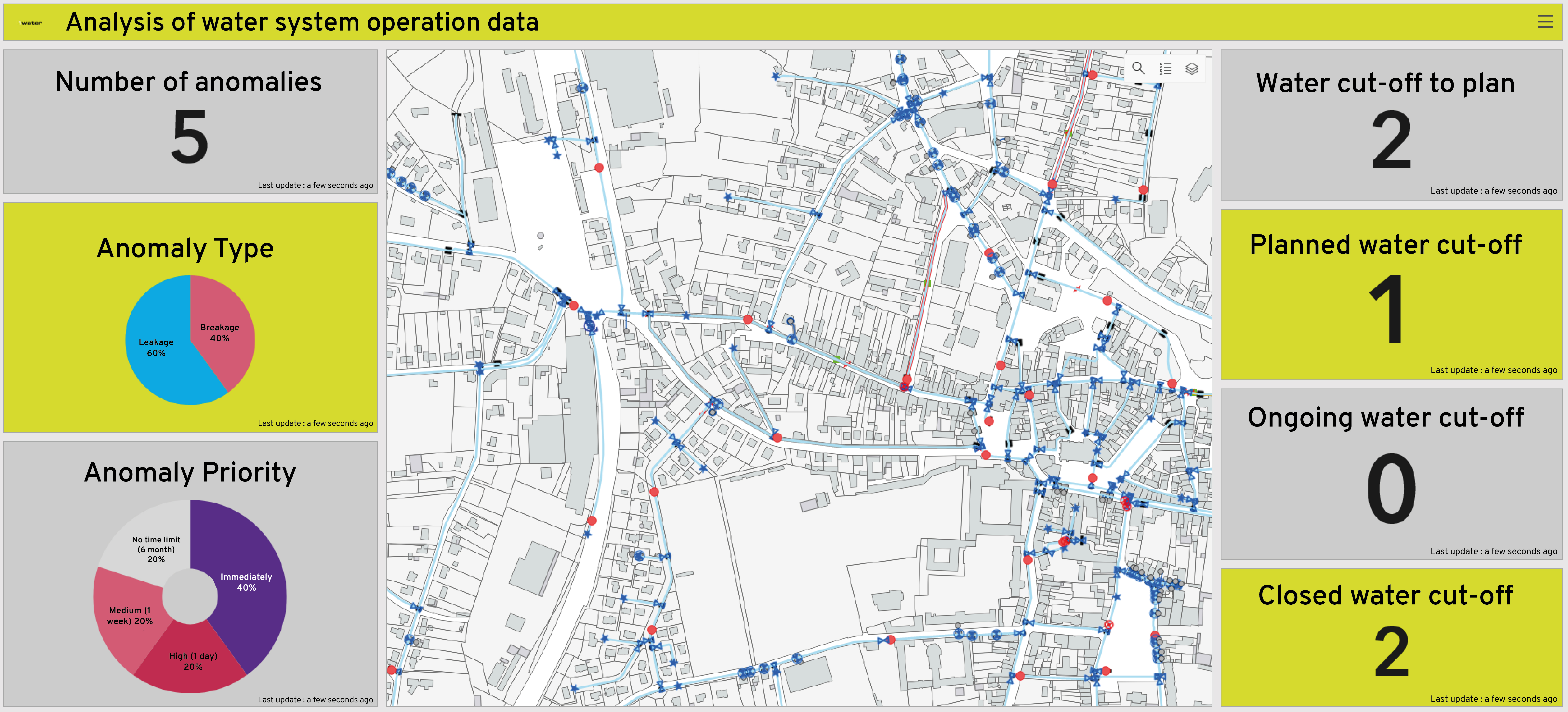
All the widgets and components revolving around the ArcGIS platform (for example, Dashboards, Insights and Mobile tools) extend our network solution to enhance real-time situational awareness.
The widgets and components make the data available through simple interfaces to the members of the organisation who need it the most: field workers, executives, managers, maintenance technicians, sales and accounting departments, and the general public.
1Water gives a full detailed view of technical, operational and managerial capabilities required to operate and maintain water and wastewater supply services in terms of quantity, quality, sustainability, reliability and cost.
- The update functions support the precise capture of your network elements and guarantee the integrity of the data with a high degree of accuracy. The system models the real world in detail and guarantees the arc-node topology.
- The IT administrator defines profiles for which he grants access rights to data and functionalities.
The different groups of internal and external users use the information according to their rights.
They consult or update data through maps and forms. - The application’s internal tools are used to monitor operations, diagnose the state of the infrastructure, schedule renewals and manage the activity throughout the entire life cycle of the asset.
Decision-making for the rehabilitation of water distribution networks in the traditional procedure is based on some simple indices such as the number of incidents while several mechanical, hydraulic and qualitative factors are taken into account in the process.
1Water helps to prioritise the rehabilitation of pipes based on different scenarios. The solution organises the wide range of data being used in decision-making models in the geographical information systems (GIS). It also uses components like queries, maps, reports, and dashboards, to help decision making.
The application integrates the management of video inspections which are carried out in accordance with the EN-13508-2 standard. The module allows the user to visualize the ITVs performed on the sections, as well as their history. By selecting a section in the GIS, you can access videos or photos, as well as information on the observations made, in the office and on the field.
The module manages preventive or corrective cleaning by associating information that can be used in the management of the network. The operator can create a map of the cleaned networks by period, use the results to plan interventions, optimize his rounds
The module provides centralised procedures for localisation, management and history of preventive interventions (systematic maintenance, tour planning, control visits), or curative interventions (clogging problems, leaks, incidents, etc.).