
Complete Geospatial Data Platform
Introducing
1Spatial by VertiGIS
We connect trusted data, actionable insight, and operational applications to help organisations turn information into action.
The acquisition of 1Spatial allows VertiGIS customers to realise greater value from their data. 1Spatial's expertise in trusted, governed data combined with VertiGIS' user-centric applications and workflow capabilities, provides a unified platform that connects data management, business applications, and operational processes. Organisations increasingly treat data as an enterprise asset, the challenge is no longer simply using data, it is ensuring that the decisions can be trusted and evidence based. VertiGIS can now bridge this gap, ensuring that the actionable insight delivered directly to the point of decision-making is based on high-quality information.
As your trusted partner, we enable you to manage the entire journey, from data quality and governance, through to automated workflows and system integration, to the applications that support critical operational and business decisions.
One organisation. One ecosystem. Better decisions.
The Missing Link in Modern Geospatial Data Platforms
Most data platforms deliver two key capabilities:
Data Foundations
Ingesting, migrating, integrating, and governing data to ensure information is accurate and up to date when assets, networks, and business operations evolve over time.
Applications and Workflows
Exposing and editing the data to transform trusted data into actionable insight through operational applications, analysis, automation, and decision-support tools.
But too often, these capabilities operate in isolation. The result:
❌ Duplicated or irrelevant data checks producing data not fit for purpose
❌ Manual workarounds causing operational inefficiencies
❌ Siloed systems creating increased operational overheads
❌ Poor business efficiencies
A Complete Geospatial Data Platform
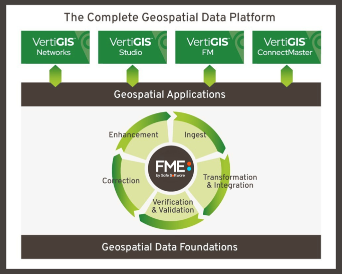
With 1Spatial by VertiGIS, these elements work together as one: Data comes in → is trusted → and is immediately usable as business information
How It Works
1. Geospatial Data Platform
-
AI-assisted ingestion and transformation of data from any source using FME
- Rules-based data quality and validation
- Enriched data through conflation of information from multiple sources
- AI-supported transformation and processing of geospatial data
→ Your data is accurate, consistent, and AI ready.
2. Geospatial Application Platform
- Geospatial applications tailored to operational and business processes.
- Workflow-driven experiences that improve efficiency and consistency.
- Intuitive tools for viewing, editing, and maintaining information.
- Actionable insight that supports faster, better-informed decisions.
→ Your data becomes actionable information across your organisation
What This Means for You
You may already have strong processes and tools in place for managing your data. You’ve invested in systems and try to maintain quality. Now, you can extend that further.
✔️ Move from maintaining data to using it more effectively
✔️ Connect governance directly to real operational workflows
✔️ Bring systems together into a joined-up environment
✔️ It’s not about replacing what you have. It’s about making it work harder.
What This Means for Our Sectors
Different Sectors. One Common Challenge.
1Spatial by VertiGIS connects the entire journey for your organisation, from trusted data and automated workflows through to operational insight, so your teams can focus less on managing data and more on acting on it.
The Outcome
From data in → to information out. A complete geospatial platform for keeping everything current.
With 1Spatial by VertiGIS:
✔️ Trusted data underpins everything
✔️ Systems and workflows are connected
✔️ Decisions are faster and more reliable
✔️ Manual effort and rework are reduced