Creating a New Project
When creating a new project, the following components must be defined:
- Dataset - either from a Template File, or defined using:
- CRS - a defined Co-ordinate Reference System
- Schema - xsd files that conform to the GML 3.2 standard
- (optional) Reflex Definition File - for using reflex methods
- (optional) GML File - data file, not required if only creating a template
 Create a New Project (From a Template File)
-
Within the Projects page, click New Project.
The Create Project page opens.
-
Under Dataset, select From a Template File.
The pre-imported Template file will be used to define the spatial definition, schema, style and rules.
-
(optional) Click Select next to Select Optional Reflex Definition File.
Select your reflex definition file from the file explorer window that opens.
-
(optional) Click Select next to Select Optional GML File.
Select your GML file from the file explorer window that opens.
Note: If loading GML, the project is named after the GML file.
-
Enter a name for your project in the Project Name field.
-
Click Create.
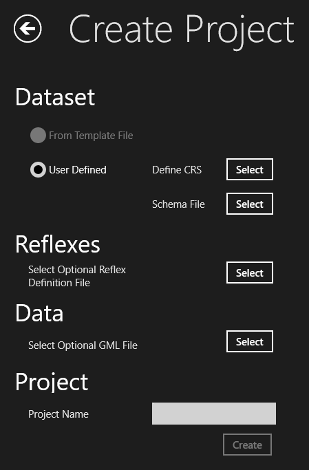
Create a new Project (User Defined)
-
Within the Projects page, click New Project.
The Create Project page opens.
-
Under Dataset, select User Defined.
You must now manually define the CRS and Schema File.
-
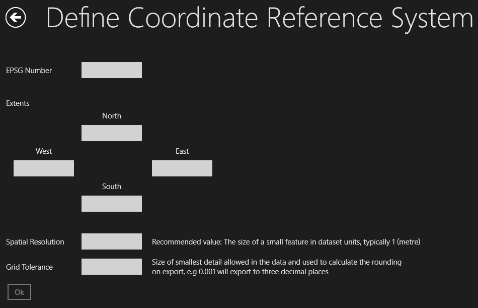
Click Select next to Define CRS.
The Define Coordinate Reference System page opens.
Enter the ESPG number, extents, spatial resolution (in metres) and the grid tolerance.
Note: The Extents do not need to be exact, but should roughly cover the expected range
of the data. Making the extents roughly accurate will improve performance.
Note: Spatial Resolution is also a performance tuning parameter and should represent the
size of a small feature in the units of the data. Typically, this is set to 1 when
the data is defined in metres.
Note: The Grid Tolerance is used to round the data. This should be a value that represents
the smallest possible difference between coordinates. For example, if you set this
to be 0.001, you are specifying that coordinates cannot be closer than 0.001 without
being considered identical. When exported, the data will be rounded to three decimal
places. When defining a topology, the topology snapping tolerance must be at least
five times this distance.
-
Click Select next to Schema File.
Select your schema file from the file explorer window that opens.
Note: Schema files are specified as xsd files that conform to the GML 3.2 standard.
-
(optional) Click Select next to Select Optional Reflex Definition File.
Select your reflex definition file from the file explorer window that opens.
-
(optional) Click Select next to Select Optional GML File.
Select your GML file from the file explorer window that opens.
Note: If loading GML, the project is named after the GML file.
-
Enter a name for your project in the Project Name field.
-
Click Create.
Dataset
A project contains a single dataset that holds all vector and raster data.
The data in a dataset is stored using a Coordinate Reference System (CRS) and conforms to a Schema.
Reflexes
A Reflex Definition File, contains the definitions of reflex methods. These are triggered
functions that are called automatically if a property on an object is modified.
Data (GML File)
Note: If you are creating a project containing no data (for example, to create a template
project), do not provide a GML file. However, if you want to load data you must provide
a GML file.
A .gml or .xml file can be provided.