
Digitising from GPS
Note: To use this feature, GPS must be enabled and your Survey Device configured (see Configuring GPS and Survey Devices).
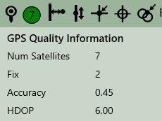
The last quality reading for GPS devices is displayed in the Context bar (see Context Bar).
![]()
Quality levels are indicated by a red, amber, or green button, with a number indicating the number of satellites that were available at the time of the reading. A grey button indicates an error.
- If the quality level is green, you can click
 and digitise points.
 - If the level is amber, you must confirm whether or not you want to use the captured position by clicking Accept or Cancel.
- If the level is red, you cannot use the current position.
- A grey button indicates an error.
Note: The quality levels refresh using the time interval entered in the Quality Refresh Interval field in the Settings menu (see Configuring GPS and Survey Devices).
Click the quality level to display more information.
If an error occurs during the capture of a coordinate reading from the GPS, a message is displayed providing further information about the error.
Continuous Capture
Continuous Capture allows you to walk along a path and capture only significant points at defined distances.
![]()
To control these parameters, use the 1Edit Survey Devices settings (see Configuring GPS and Survey Devices). You can control how the minimum distance apart to capture points (Distance Tolerance in dataset units) and how far to deviate from a straight line before capturing a point (Angle Deviation Tolerance in degrees).
Points are only captured if they are at least the Distance Tolerance away from the previous point and if more than the Angle Deviation Tolerance away from a straight line from the previous two points. This prevents several redundant points being captured along a long, straight line.

Copyright © 2017 1Spatial

