3D
1Integrate 3D delivers a master data management approach for managing 3D data alongside 2D and 2.5D data in a single data processing environment.
3D Data Management
Organizations who deal with 3D data can also benefit from 1Spatial’s automated rules-based approach to data quality, data integration and data enhancement using 1Integrate.
Data with 3D geometries has been used for a long time in design/construction projects but increasingly also by national mapping and government agencies. The use of BIM as a discipline for whole-life asset management is also driving the need for an automated data quality approach, especially when trying to use 3D data alongside traditional 2D or 2.5D GIS data.
1Integrate 3D allows you to:
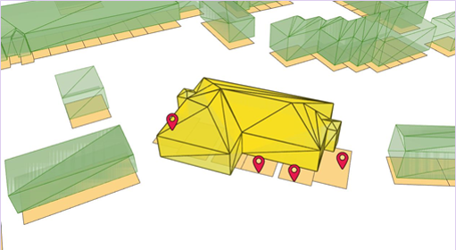
- Inspect and validate 3D data (such as checking for overlapping buildings or ensuring that the walls, floor and roof of a building form a closed shell)
- Ensure alignment between 3D and 2D data by checking and improving the positional accuracy
- Use automatically captured 3D objects to perform change detection using fuzzy spatial comparison with existing data
- Automatically creating internal rooms from building floor plans
- Automatically forming solids from the surfaces that surround it
- Validate BIM models against required business rules, for example to ensure that suppliers are meeting their data delivery obligations or to transition design and construction data through to ongoing maintenance
This enhanced capability will enable customers to more accurately manage aspects such as sunlight availability, noise propagation, building heat loss, intelligent taxation, underground asset management and trench planning, solar panel capacity or building occupancy. These are typical requirements for facilities management, smart cities or infrastructure management sectors.

Automatic change detection of 2D assets using 3D data
1Integrate 3D and 1Data Gateway
1Integrate and 1Data Gateway deliver a master data management approach for managing 3D data alongside 2D/2.5D data in a single data processing environment. They allow you to measure 3D data quality, identify 3D data errors (such as misaligned or invalid data), allow positional improvement as well as geometric enhancement of the data by comparing 2D, 2.5D and 3D data.


