City of Marseille

 Marseille creates a central source of geospatial truth
Marseille is France’s second largest city. Inhabited since prehistoric times, the city now has a population of 860,000 and is a major centre of trade and industry. Marseille, like many large, modern cities, is particularly concerned with developing the local economy and managing the local environment; creating an attractive place for people and businesses to locate.
Geospatial data is central to many of the issues the city needs to manage and it has recognised that efficiently sharing authoritative data is an important function. Pascal Giansily, the GIS Manager for Marseille, explains, "our goal is to provide the tools and address the specific data needs of the municipalities: business-oriented data for city managers."
The challenge of managing data for many users
Marseille’s geospatial data had traditionally been held in isolated “silos” within different city departments and across the city’s arrondissements. Sharing data from many sources with a wide set of users quickly exposes any inconsistencies and the City had experienced some problems with data quality as a result.
Marseille also shares some management responsibilities (and related data) with the wider Urban Community of Marseille Provence Métropole (MPM, a group of 18 neighbouring towns, centred on Marseille). For example,
Marseille is responsible for public lighting and parking areas, but the geospatial data relating to the roads is the responsibility of MPM. Similarly, responsibility for schools, green spaces or public sports facilities sits with Marseille, while MPM is responsible for all surveying and for short-term events such as Marseille’s role as European Capital of Culture (in 2013).
Access to geospatial data and tools was restricted to users of PCs with the necessary desktop applications. Separate applications were required for different functions such as topography, GIS or CAD. IT management of these tools was a time-consuming burden, as each PC had to be visited and updated
individually.
Marseille’s GIS team wanted to simplify the administration and management of its geospatial data and tools. In doing so, the team saw that they could make consistent, business-oriented data more widely available and thus speed up decision-making for city managers.
A single source of authoritative data
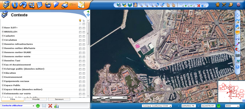
Marseille put the project out to tender and, having assessed all submissions, chose a proposal from 1Spatial. Together, 1Spatial and Pascal Giansily’s team developed a GIS solution that centred on a single, central data warehouse (an Oracle Spatial database, known to the team as the Unitor) accessed by 1Spatial’s Elyx Web software.
The Unitor centralises all geospatial data, ensuring it is consistent, properly managed and authoritative. The data is managed using 1Spatial’s Elyx Manager desktop software. Marseille also has 20 full Elyx Office desktop licenses for “power-users”. However, 2,600 other users (across the City of Marseille and MPM) now use Elyx Web, a web-browser based application, to access the geospatial data they need.
Pascal Giansily explains, "the Web solution lets us centralise IT management and save time by not updating every workstation individually. It also has big advantages for how users access different services. Before, everything was done on separate PC applications. The web was only used for sharing results. Now, thanks to the 1Spatial solution, we even get to do the drawing over the Web."
Marseille now offers city managers 1,000 layers of geospatial features, sorted bytheme. These include networks and cabling, urban planning, parking, taxi data and video protection. Updates are fed into the Unitor through Elyx Web so that the single, central database remains authoritative and there is no duplication or inconsistency. As Pascal Giansily says, "everything is centralised and managed within the data warehouse. It’s very powerful!"
Seamless and efficient data-sharing
Accurate, relevant spatial data can now be accessed by any authorised user without the need to negotiate with different departments. The improved access and increased recognition of the value of spatial data means that Marseille’s data is being used to improve decision-making in more and more scenarios. For the European Capital of Culture events, a project team used Elyx Web to easily create a list of potential event sites complete with information on safety requirements and capacity.
Elyx Office is used to manage wards and boundaries for local elections.
The city’s Event and Party department manages applications for public events such as cycle racing or markets. The department checks each application with other city departments and emergency services to ensure there are no planned road-works or other potential problems before issuing an authorization. The team now uses Elyx Web to display the event location and all relevant layers of information to anticipate any issues. The popular television soap opera Plus Belle la Vie is set in Marseille and the producers make regular requests to film around the Vieux Port area of the city. Again, Elyx Web speeds up decision-making by enabling all city departments to quickly share relevant information.
Making information public
Marseille’s geospatial data warehouse can easily feed data to other applications, enabling the city to share valuable information with residents and visitors. For example, Marseille now automatically produces public information on urban planning applications, removing what was a regular administrative bottle-neck.
Information on the location of public facilities such as schools, town halls and car parks is also fed to a public web portal.
Looking to the future
Pascal Giansily and his colleagues continue to add new data sets to Marseille’s data warehouse, further increasing the value of this central, authoritative view. At the same time, departments all across Marseille are finding new applications for their geospatial data. Over the next few months, users from across MPM will have training sessions on Elyx Web, further extending the number of users and the number of applications for Marseille’s data. Several departments are exploring how they can use data to locate employees and equipment as they move around the city.
Another team is using the data to assist in the placement of CCTV cameras. This is city’s first use of three-dimensional geospatial data and it uses Elyx 3D’s intervisbility capability to check the angle of a new camera for potential blind-spots, shadowed areas or buildings obstructing the view. Pascal Giansily is keen to explore further uses for Elyx 3D and the possibilities that three-dimensional data offers. However, only a small amount of 3D data is currently stored and increasing this would require budget for additional survey work: a project for the future.
As Pascal Giansily notes, "the 1Spatial solution is ideal for everything related to data administration. Our challenge now is collecting new data, rather than managing the tools."