3D in Geocortex Web
Written by Aled Nicholas, Senior Consultant, 1Spatial
 Geocortex Web (GXW) is a next-generation framework for creating sleek and effective GIS applications. The apps allow users to view and interact with web-based maps and the associated data. There are several great features available in GXW, which will become apparent, although I’m going to focus on 3D and the different layouts available for the display and analysing of 3D mapping.
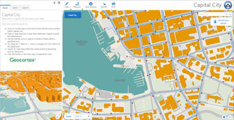
First of all, in order to add 3D data into GXW a 3D scene must be created. This can be a scene that is published to either Portal for ArcGIS or ArcGIS Online. When you open GXW, you are presented with a number of templates, some of which are specifically designed for use with 3D data. All of these viewers are highly configurable, allowing you to really customise the app based on your requirements. Alternatively, you could also configure the viewer yourself from blank. The layouts that are intended for use with 3D are:
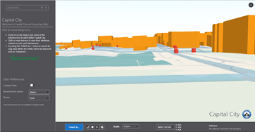
3D Scene Viewer
This template includes a menu panel and a number of widgets, which are centred around a map window that displays the 3D scene. As a relatively straightforward layout, this could be used as a standard 3D viewer in any number of different business scenarios i.e. to visualise developments in town planning, the display of flood modelling data within the terrain or any form of visibility mapping, such as wind farm visualisation.
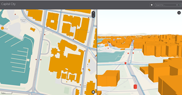
2D-3D Information Access
Includes a limited set of widgets and is focused on a split 2D/3D screen. The divider can be easily adjusted so that the main focus can be either 2D or 3D or split equally. The map windows are linked, so that any navigation carried out in one window is replicated in the other window. Just picture how useful this could be for a utilities company to view their assets underground. They could quite easily have a 3D viewer linked with a 2D viewer that shows where a subsurface repair is required.
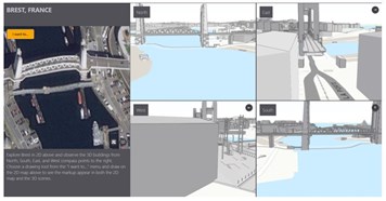
Compass Points
This viewer shows a central point, and then the 3D scene from each compass aspect. This could be useful when focusing on a particular building or feature and then viewing it from all angles. Each map window is navigable and if the centre point is changed, then each of the compass aspects updates too. You can see how useful this could be for transportation, showing the relative height of the bridge and making it easy to identify where routes cross over i.e. where there is a bridge over a road, rather than a river.
2D-3D Multi Layout
Similar to the 2D-3D Information Access, but a home panel is also included. The home panel and the second viewer can be adjusted, as can the main viewer. The home panel also includes tabs for additional information.
In Summary
So, we can see that pretty much any requirement for a 3D viewer is covered by the templates included in GXW. From there, only a minimal amount of work is required to complete your 3D viewer.
GXW really does take the hassle out of creating a 3D viewer, with no compromises needed between 2D and 3D, or which is the main focus of the viewer. The GXW viewer templates give you the option to create exactly what you need. In addition to this, GXW can be integrated with other Geocortex products, such as Workflow, Reporting and Printing, truly taking the capabilities of GXW as a 3D viewer to another level.
To find out more please get in touch.
Register for one of our upcoming Geocortex webinars – Click here