A new decade and a new public sector geospatial agreement
A new decade and a new public sector geospatial agreement supporting public sector geospatial readiness
The Last 10 years
During the past 10 years the Public Sector Mapping Agreement (PSMA) has helped shape and evolve the use of geospatial data across the public sector.
A New Agreement
Last week the Geospatial Commission announced a new Public Sector Geospatial Agreement (PSGA) with Ordnance Survey for the next 10 years. Any public sector organisation ranging from health and emergency services through to central government departments can sign up via Ordnance Survey to use geospatial data, free at the point of use.
Supporting the Evolution of Geospatial Data Infrastructures
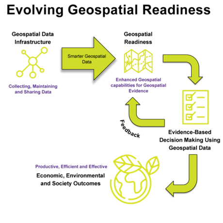
In my last blog article in January 2020 I talked about a new decade and new emerging approaches to evolving geospatial data infrastructures across government. In my December 2019 blog article, I talked about making data easier not harder to work with. The new PSGA will enable the continued evolution of geospatial data infrastructures across the public sector, making geospatial data easier not harder to work with. Consequently, this will evolve organisation, regional and national geospatial readiness, enable evidence based decision making, to meet economic, environmental and society needs during the next 10 years.
Supporting Sustainable Impacts from Data
The PSGA will help ensure positive and sustainable impacts from data. Evidence-based decision making requires data of an appropriate quality that is transparent, defined and measured. OS is a provider of authoritative geospatial data that will support effective evidence-based decision making.
Supporting the Development of Data Strategies
Underpinning data infrastructures are data strategies, helping organisations to clarify the primary purposes of their data and guiding organisations with strategic data management. In a new decade the PSGA will support the development of data strategies, ensuring that geospatial is an integral part of an organisation’s investment in data and exploitation of data.
Supporting Defensive and Offensive Data Approaches
During the past 10 years the PSMA has enabled the development of defensive approaches to managing geospatial data infrastructures, for example; OS MasterMap. Organisations across the public sector have designed and implemented efficient centralised approaches to managing and making available OS MasterMap data. The new PSGA will support the continued evolution of defensive approaches and the adoption of offensive approaches.
Organisations increasingly need both defensive and offensive approaches to managing geospatial data infrastructures. The more uniform data is, the easier it becomes to execute defensive approaches, such as complying with legislation or policy requirements and implementing data-access controls. The more flexible data is, the more readily it can be transformed or interpreted to meet specific business needs—the more useful it is in offense. In a new decade the PSGA will support both balancing data control and data flexibility.
1Spatial Experiences across the Public Sector
In the last decade 1Spatial has supported many public sector organisations to evolve their geospatial data infrastructure enabled by the PSMA. Organisations have often developed highly centralised, control-oriented approaches to geospatial data infrastructures using OS data. These approaches have been effective for standardising enterprise geospatial data, governing structured data formats for connecting geospatial data with the business processes that consume it.
However, changing demands and expectations for data mean that these approaches could restrict flexibility, making it harder to customise data or transform data into information. In a new decade 1Spatial think that public sector organisations will need to adopt more flexible approaches to geospatial data infrastructures using the PSGA, governing processes and rules that convert authoritative OS data into useful information. This will mean involving both a single source of truth (SSOT) and multiple versions of the truth (MVOTs). SSOT works at the OS data level, whilst MVOTs support the management of information.
Working with Public Sector Organisations in a New Decade
Changing demands and expectations requires that geospatial data contained in an organisations SSOT geospatial data infrastructure is of high quality, granular, and standardised, and that multiple versions of the truth (MVOTs) are carefully controlled and derived from the same SSOT. Enabled by the new PSGA 1Spatial will endeavour to continue supporting the evolution of public sector geospatial data infrastructures, growing geospatial readiness, benefiting our economy, environment and society.
Get in touch, if you would like to discuss this further with our government team.
Author Matthew White, 1Spatial