

Embracing frameworks for data and information management
Embracing frameworks for data and information management across government
Adoption of Frameworks
The adoption of frameworks and corresponding pathways for data and information management across government has increased over the past few years and it has accelerated during the past 12 months.
COVID-19 has highlighted the need to invest in frameworks, systems and infrastructures, methods, and people for collecting data, maintaining data, and storing it in a ready-to-share way. Frameworks for data and information management are the foundations for enabling actionable information, benefiting our economy, environment, and society. Actionable information is needed to undertake “rear view mirror” assessments, drive changes in the here and now, and shape the future. The adoption of frameworks is accelerating, improving delivery and in turn enabling more effective decision making for tackling COVID-19 recovery, economic inequality, and climate change.
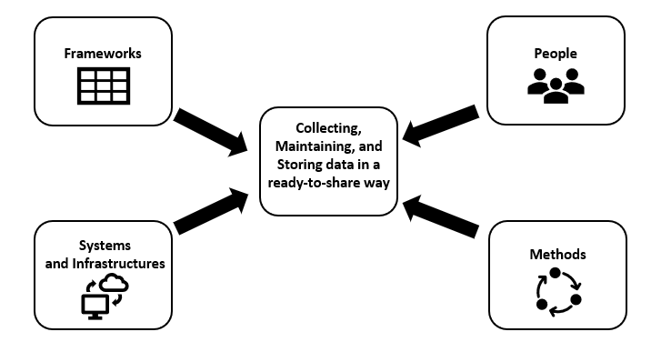
Frameworks, Systems and Infrastructures, Methods and People
1Spatial embracing Information Management Frameworks
I would like to reference three specific information management frameworks that 1Spatial is embracing, enabling government organisations to evolve the way they manage and share location data. Firstly, the United Nations endorsed 'Integrated Geospatial Information Framework'. Secondly, the Centre for Digital Built Britain 'Pathway Towards an Information Management Framework for the built environment'. Thirdly, the 'Government Data Quality Framework'.
United Nations Integrated Geospatial Information Framework
'The Integrated Geospatial Information Framework (IGIF)' was developed in collaboration between the United Nations and the World Bank, originally to provide a basis and guide for lower to middle income countries to reference when developing and strengthening their national and sub-national arrangements in geospatial information management and related infrastructures. However, as the framework has evolved, it has become apparent that many high income and developed countries will also significantly benefit from the framework.
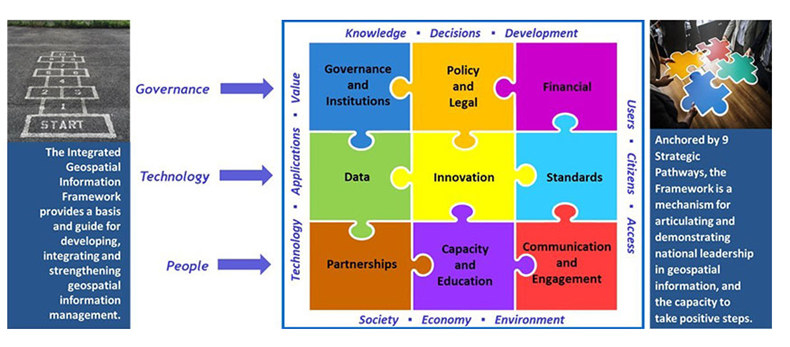
United Nations Integrated Geospatial Information Framework
Geospatial information has been typically collected in organisational silos; resulting in possible data duplication, and the use of different standards, formats and classifications. This has made data integration and data maintenance problematic. The IGIF framework includes 9 strategic pathways, 3 with a strong technology focus: Data, Innovation, and Standards.
The data strategic pathway establishes a geospatial framework and custodianship guidelines for best practise collection and management of integrated geospatial information. 1Spatial aim to help government organisations and their user communities meet their data management, sharing and reuse obligations. 1Spatial’s Platform adopts our Location Master Data Management (LMDM) approach to ensure that data management can be automated and repeatable within and across organisations.
The innovation strategic pathway recognises that technology and processes are continuously evolving, creating enhanced opportunities for innovation and creativity that enable government organisations to quickly bridge the digital divide. Our innovative approach allows for affordable data management improvement by cleansing, matching, synchronising and analysing different data sets automatically, both ad hoc and at point of entry. We help government to leapfrog to state-of-the-art data and information management systems and practices.
The standards strategic pathway establishes, and ensures the adoption of, best practice standards and compliance mechanisms that enable legal, data, semantic and technical interoperability, which are fundamental to delivering integrated geospatial information and knowledge creation. 1Spatial’s LMDM approach enables different government information systems to communicate and exchange data via Application Programming Interfaces (APIs). We adopt best practice and open standards for data and information management.
Centre for Digital Built Britain Information Management Framework
'The Pathway Towards an Information Management Framework: A Commons for a Digital Built Britain' report sets out the technical approach for the development of an Information Management Framework to enable secure, resilient data sharing across the built environment. The publication of the report by the Centre for Digital Built Britain, in partnership with the Construction Innovation Hub, is a critical milestone towards a National Digital Twin.
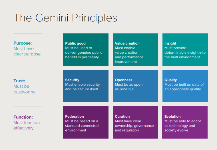
There is a need for a common set of definitions and principles that can be adopted to underpin the development of digital twins and a national digital twin across the built environment. The Gemini Principles paper, released in 2018, proposed principles to guide the national digital twin and the information management framework that will enable it.
Centre for Digital Built Britain Gemini Principles
1Spatial is helping government organisations to begin alignment on the approach to information management across the built environment by focusing on Trust, making it easier to share data in the future. Using 1Spatial’s LMDM approach we are adopting open data, open standards, and collaborative models to build trust, reduce cost and create more value from data. We are using technology and processes to ensure that digital twins are built on data of an appropriate quality for the purpose to which it is put. The success of digital twins will be judged on the quality of decisions they enable. 1Spatial is ensuring appropriate data quality by defining and using standards and rules. These can then be automated using technology and processes.
Government Data Quality Framework
'The Government Data Quality Framework' is a commitment made in the UK National Data Strategy under the Data Foundations pillar. The National Data Strategy recognises that by improving the quality of data, we can drive better insights and outcomes from its use. The Government Data Quality Framework is an integral part of the strategy’s commitment to tackle the cultural and coordination barriers to good quality data, and to ensure that the true value of data is realised. The framework focuses primarily on assessing and improving the quality of input data rather than the quality assurance of analytical outputs.
The Framework guidance provides a set of practical tools and techniques which can be used to assess, communicate and improve data quality. 1Spatial is assisting government organisations to develop data quality action plans, identifying practical steps to assess data quality and make targeted improvements. We are doing this by identifying critical data and data quality rules, performing initial data quality assessments, measuring data against data quality rules, reporting data quality findings, prioritising, and actioning data quality improvement. 1Spatial’s Platform adopts our LMDM approach for provisioning practical steps to assessing data quality and making targeted improvements.
Government organisations adopting frameworks
These frameworks are intended to provide the strategic guidance that enables better information management at national, regional, and local levels. Government organisations are beginning to adopt these frameworks and evolving their systems and methods to collect, maintain, store, and share digital data and information.
Tailte Éireann Surveying is delivering new digital services, developing its data platforms, and strengthening its underlying systems to make it easier for everyone to benefit from authoritative geospatial information. They are beginning to adopt the United Nations Integrated Geospatial Information Framework and Pathways.
The Environment Agency in England is transforming how it collects, assures, stores, and shares digital data about flood defence assets. They are doing this by adopting the Centre for Digital Built Britain Pathway Towards Information Management Framework and Gemini Principles. 1Spatial is delighted to be working with both organisations, applying our LMDM approach and tools.
The UK Geospatial Commission has chosen to adopt the United Nations Integrated Geospatial Information Framework for implementing a national location data framework that is consistent with the IGIF. The Geospatial Commission will continue to develop the UK’s national location data framework in a way that recognises the need for compatibility with relevant international best practice and aligns with the government’s wider data policy approach and priorities.
Our approach and tools
1Spatial is assisting government organisations to implement pathways for data and information management, including strategic pathways for data, innovation, and standards using technology.
The LMDM approach we take and tools we offer for embracing information management frameworks follows learning by doing, overcoming by sharing and succeeding together through data collaboration, data automation, data transformation, data validation and data visualisation principles.
- Data Collaboration – working with employees and stakeholders internally and externally to share data management responsibilities and connect authoritative and actionable data at local, regional, and national scales using 1Data Gateway and our Location Master Data Management approach.
- Data Automation – operationalising automated data workflows to manage and share authoritative and actionable data at local, regional, and national scales using 1Data Gateway, 1Integrate, FME and Geocortex.
- Data Transformation – making data fit for purpose by transferring and transforming data between data source(s) and target interface(s) using Safe Software’s FME and 1Integrate.
- Data Validation – ensuring data is both correct and complete using 1Integrate.
- Data Visualisation – making authoritative and actionable information accessible using VertiGIS’s Geocortex.
We are supporting organisations across government to adopt information management frameworks and subsequent pathways, benefiting our economy, environment, and society. Frameworks are helping government organisations evolve their systems, infrastructures and methods for data and information management.
Find out more
If you would like to find out more about how we work with government organisations to connect and unlock the value of location by adopting information management frameworks, please contact us.
Author: Matthew White, 1Spatial