1lntegrate 4.2 leverages inheritance for less taxing rule building

1Spatial, the global leader in location master data management solutions that improve data quality and governance, is pleased to announce the latest release of 1Integrate for automated data validation and enhancement.
Improved Ontology and Reference support means a streamlined process for those using linear reference systems (such as Departments of Transportation) or any hierarchical data model, including 1Spatial customers in the Public Safety sector where it is crucial to be able to quickly and easily update rules to ensure compliance.
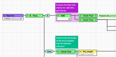
Other enhancements to the rule-building experience include colour-coded comments, ensuring the no-code rules and actions can be easily interpreted and re-used by others. You can also focus on just one node, reducing the complexity of a larger rule and allowing you to concentrate on the important logic. These enhancements, plus others, make your rules easier to navigate and easier to manage over time.
Two new CAD datastores have been added, supporting DWG and DGN file formats, to aid Built Environment customers using these two most common CAD formats without having to use third-party tools.


Charley Glynn, Senior Product Manager, 1Spatial says “With this latest release of 1Integrate, we are continuing our focus on improving the user experience for rule builders. Since releasing the new user interface (UI) earlier this year we have continued to work with our users to make enhancements that increase their productivity.
Features such as colour-coded comments may seem like a fairly small change in isolation, but when paired with other UI updates, they can be game changers. I am especially excited to see how users leverage the improved ontology support and new native CAD Data Stores that can now be accessed on our SaaS platform for the first time.”
Bob Chell, Chief Product Officer, 1Spatial added “The validation of CAD data has always been important for many of our customers, from utilities to government, from transport right up to our customers like Google. Today, there is further interest in not just validating CAD, but also integrating it with GIS data. Our updates in this version of 1Integrate recognise that this is an area we are continuously focusing on and improving.
As systems and models are becoming more and more flexible, the ontology improvements we’ve introduced will benefit many of our customers. Those working with models like IFC and the Esri ArcGIS Utility Network will all benefit from these new and improved features, and will help them stay ahead of their competition.”
Contact us for a demo
or to access a trial to give it a go yourself!
Fill in your details and we'll be in touch to help you get the most out of your 1Integrate trial.
Some of the benefits you'll receive are:
- Take 30 days to test out your ideas.
- Take a self-paced tour through our on-line training.
- If you get stuck, our expert team are always on-hand.
- Seamlessly move from Trial to Production or Cancel anytime.
- No Credit Card required
- No additional software required
- No IT support needed
- No desktop app downloads required
- No installation time or need for IT
Read our trial FAQs for more information.

