Ordnance Survey Northern Ireland

Spatial unlocks the key to joined-up government
Overview
OSNI Fusion, a new data model developed by Ordnance Survey of Northern Ireland (OSNI) together with
automation, editing and integration tools from 1Spatial provide the opportunity for Land & Property Services
(LPS) to link databases and automate processes across government.
Challenge
Formed by the merger of OSNI, Land Registry, Valuation Agency and Rates Collection Agency, LPS has a wealth of data relating to land and property. However, with the information held in separate legacy systems preventing it from being shared both within the organisation and across government, it needed a new building block for interoperability.
Furthermore, as LPS data underpins the collection of around £1.3 billion of rates revenue, the solution would
also need to retain user confidence in accuracy and quality, as well as capture and management methods.
Solution
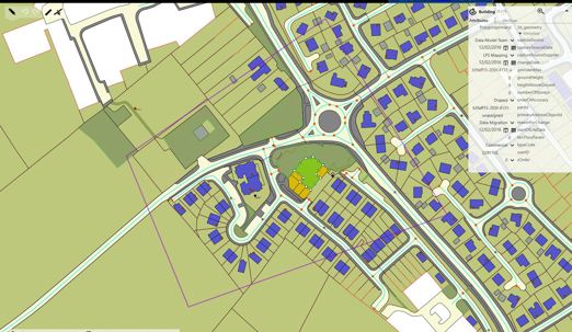
Developed by OSNI, the Fusion object-based model has created millions of features to represent Northern Ireland’s land use and built environment, each with a unique spatial identifier. The linkages created by these identifiers geolocate any building, land parcel or other real world object to join up systems across government and create an integrated geospatial information framework. They are also used within the 1Spatial Management Suite (1SMS) to provide a fully automated workflow for capturing and managing change in the national database. Unique identifiers are also enabling the automatic trigger of multiple business processes, so that every user across government is kept informed of changes.
1SMS provides the spatial data infrastructure to manage the object lifecycle and a quality framework which ensures data is subject to validation checks before integration and acceptance into the live system. In addition, the unique identifier provides confidence that quality is retained throughout the object’s lifecycle.
“Embedding the unique identifier as a requirement in new systems is an opportunity for the Northern Ireland Civil Service to leapfrog the rest of the world in their application, making us global leaders in supporting joined up government.”
Jim Lennon, Chief Survey Officer & Director, Ordnance Survey Northern Ireland
Project Benefits
- Joins up systems across government via a geospatial information framework
- Ensures data quality whilst improving efficiency using automation for verification against specifications
- Maintains a live publication-ready production database as only changes conforming to OSNI business rules are accepted
- Saves time and costs by enabling office-based editing of database changes with no ground survey required – a team of nine can now complete the same volume of work as a team of 25
- Quality enforced through a spatial data infrastructure
- Enables daily update of OSNI large-scale, off-the-shelf products through constant application of change-only updates
- Provide the ability to deliver updates to customers on-demand rather than quarterly by aligning overnight product updates with change-only update of national database
- Minimises data duplication, re-collection and improves data quality
- Delivers products that can be integrated more easily and efficiently with other data by both LPS and its customers