

Eurométropole de Strasbourg

 Strasbourg shares “richest geographical database in France”
Eurométropole de Strasbourg (Strasbourg) is a metropolitan district centred on the city of Strasbourg. It covers an area of 316 km² and comprises 28 separate towns with a combined population of 500,000 inhabitants, 43 per cent of the total population of the Bas-Rhin department. Strasbourg is also the seat of the European Parliament.
Michel Rosio is the Head of the Geographic Information and Development Department
within the Information Systems, Telecommunications and Networks Service. The department’s role is to manage geospatial projects and to support the users of geospatial applications both from Strasbourg city and the wider Eurometropolis. Strasbourg has been at the forefront of urban mapping and geographical information systems (GIS) for many years, dating back to the detailed cadastral maps created during the Napoleonic era.
In the 1970s, Strasbourg began a detailed survey to supplement its 75,000 cadastral plans. This information was used to create very accurate topographic maps at a 1/200 scale, which were stored on A0 sheets of film. When, in 1991, the region developed its first GIS system, this information formed a rich starting point. Michel Rosio notes, “The database was homogeneous and consistent, with the same wealth of information and the same content regardless of where you looked, whatever the scale.”
Strasbourg was also an early leader in sharing geospatial data with partner organisations such as the managers of local networks (electricity, gas, telecommunication). These organisations co-funded development of this base map.
Updating systems to increase data sharing
Strasbourg had been an early adopter of GIS systems and, over time, it had developed a number of internal systems. By 2005 however, all developments to its former GIS had ceased leaving them experiencing a number of interoperability challenges between these systems. Data frequently had to be copied or manually converted between different applications and too much work was being duplicated. This not only wasted time and increased cost, it also introduced the risk of inconsistencies and manual errors.
Strasbourg wanted to move to an integrated GIS system, based on Oracle and Windows (rather than the Sybase and UNIX-based system it was using) to address these issues.
The district also wished to extend access to geospatial data beyond its formal partnerships to any citizen or organisation. It wanted to offer new geospatial services to residents and to create an API so that people could access the data as open data. However, 13 different services had made daily use of the metropolis’s
data from its existing system for over ten years. In migrating to any new solution, it was essential that no users be lost or cut off from the data they relied upon.
A single source of authoritative geospatial data
Michel Rosio and representatives from the different services developed requirements for a new system and invited interested companies to tender for the project. During a demanding audition process, each vendor had to present 70 different functions, from a data set provided by Strasbourg, to ensure they could meet Strasbourg’s requirements. Because of the size of the database and the number of different users from different business and organisations, it was essential that the solution enabled robust management of access rights at a very granular level.
Strasbourg selected 1Spatial as best meeting their requirements and the two organisations worked closely to develop a solution built on 1Spatial’s Elyx Suite. “We had to guarantee the continuity of service during the data migration process,” explains Michel Rosio. “This was not easy, and it took time.”
"The level of collaboration with 1Spatial was intense and we had some pretty sophisticated technical discussions with a high level of expertise from both sides."
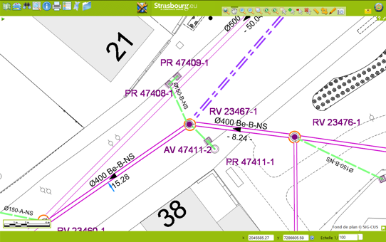
The resulting database contains 10 million features including 200,000 parcels of land, 150,000 buildings and 1,500km of road. It has over 1,000 separate classes of feature. As Michel Rosio explains, "users have access, through Elyx Web, to over 50 different default themes for networks and feature sets such as the water and sanitation system or lighting. It is one of the largest and richest databases in France and there are few equivalents in Germany or Switzerland. The system is envied by our colleagues in other regions of France, because we have such a high quality and precision of information and a solution that is fit for purpose."
The Elyx solution deployed by 1Spatial covers over 1,700 users including 300 external partners. Access rights are controlled by Elyx Manager, which interoperates with Strasbourg’s existing, in-house rights management system.
The team planned a gradual migration over a four-year period to ensure that existing services were not disrupted and that users, some of whom had used the original system for 15 years, could become familiar with their new GIS tools.
Interoperability saves time and boosts collaboration
Michel Rosio explains, “Elyx is now our repository for geospatial data. It is the heart of our geospatial system and disseminates information to all other tools which use geospatial information. The source of data is always managed within Elyx.”
Users can now switch easily between applications and dynamically join data without the need for error-prone, manual copying between systems.
With a single, common data set, one set of geospatial symbology and one management and admin process, Strasbourg ensures quality and saves time and money.
Collaboration between users and departments is simpler, too. Data and documents can now be easily exchanged using standard Microsoft Office and Windows file formats.
Open data for a smarter city
Strasbourg has developed StrasMap, a free application for residents and visitors that provides real-time information on traffic, road works, parking places, air quality and snow clearing. StrasMap enables users to check timetables for public transport, to check the availability of city bikes or car shares and to plan their itinerary accordingly.
The app (Apple, Android or web app) is free and available in French, English and German. It is fed data by Strasbourg’s Elyx solution. StrasMap received an award of “Innovative Territory” at the prestigious Forum des
Interconnectés in 2011 and it is currently being downloaded 1,000 times per month.
Strasbourg has also developed its open data API and now makes more than 50 data sets, many of which include geospatial data, available through its open data website.
Easier data sharing with partners
Strasbourg shares geospatial data with a great many partners. Special partnerships have been contracted with network and public operators like managers of local electricity and gas networks, the Syndicat des Eaux et de l’Assainissement Alsace - Morelle (SDEA) and France Telecom Strasbourg. Some of these are co-financing the management of Strasbourg’s geospatial data.
Strasbourg is also partnered with France’s urban planning agency and, through the Strasbourg-Ortenau Eurodistrict, with organisations in Germany.
The Elyx solution has enabled Strasbourg to improve its data-sharing services, improving interoperability and automating some data exchanges processes with Elyx ETL.
Staying ahead
Strasbourg intends to remain at the forefront of digital development. In April 2015, Shadok – Strasbourg’s “digital factory” – was opened by Axelle Lemaire, the French Minister for Digital Affairs. The digital factory is intended to develop access to digital media for all citizens, students, start-ups and professionals. It will also promote innovation.
Recently, Strasbourg and the neighbouring city of Mulhouse joined forces to develop their digital ecosystem and they received the French Tech award, with the distinctions in Med Tech and Bio Tech.
In these and other developments, geospatial data will be central. Michel Rosio and his team also have plans of their own to further develop the use of three dimensional geospatial data. As Michel Rosio says, “We can no longer manage the city in two dimensions, with just some 3D visualisation. We must achieve a full 3D visualisation model in the future and even, in the long-term, ‘4D’, by reducing the differences between the database and reality in the field.”
"From now on, we will focus on citizen-oriented projects and smart city services, explains Michel Rosio. Our goal is to enrich the level of functionality, and to develop value-added services for the citizen.
The current challenge for Strasbourg, which became Eurométropole on the 1st of January 2015, is to use its new expertise to support technology transfer between businesses in the city’s innovation hub, and to enable the city to fully play its role as European Capital City."