1Spatial World Tour 2025
Join us for
1Spatial's World Tour 2025 Featuring FME
We’re excited to welcome you to the 1Spatial World Tour 2025, featuring FME... your gateway to the latest in data innovation and the power of FME. Join us for a day of inspiration, learning, and collaboration as we bring industry experts, thought leaders, and peers together under one roof.

Beyond Today: The Future of Spatial Data
The 1Spatial World Tour 2025 is where innovation meets insight. This year’s theme, “Beyond Today: The Future of Spatial Data,” takes you on a journey into the cutting-edge of location data management. Discover how advancements in automation, integration, and AI are reshaping the spatial landscape, not just for today, but for the future. From driving smarter decisions to unlocking the power of geospatial, non-spatial and unstructured data, we’ll show you how to future-proof your workflows and maximise the value of your data.
Gain exclusive takeaways from the FME User Conference 2025, including the latest in FME 2025.0 features that bring AI directly into your processes through the "All-Data, Any-AI" approach. Learn how to boost your return on investment with best practices, cost-effective license use, and new functionality. We’ll also explore seamless integrations with platforms like Azure Power Platform, Databricks, and Snowflake, enabling powerful cross-platform data collaboration and consistency across your organisation.
Whether you're just starting out or have years of experience, this event is designed for new, beginner, and advanced users of FME, offering value at every skill level.
For technical professionals, we’ll deep-dive into enhanced data transformation capabilities, improved engine efficiency, and expanded support for real-time processing. Explore how FME ensures data integrity across complex environments through robust translation, validation, and automation tools. Whether working with spatial, non-spatial, or unstructured data, you'll learn how to streamline workflows, minimise disruption, and maintain accuracy at scale.

What to Expect at the Event
- Spotlight on FME 2025: Discover the latest features and enhancements in FME 2025, including performance upgrades, AI integration, and the latest updates released at the FME User Conference in May 2025.
- AI Assist: reimagine what’s possible with data and AI, explore real-world use cases and practical applications of FME and AI, with live demonstrations showcasing how to integrate AI Agents into your workflows.
- Customer Success Stories: Be inspired by real-world case studies that highlight how organisations are leveraging FME to solve data challenges.
- Data Challenges Session: Submit your FME challenges in advance, and our experts will discuss solutions in a collaborative workshop session.
- FME Doctors: Have a problem with your FME workflow? Have a one-to-one session with our FME experts!
- Interactive Q&A & Networking: Engage with industry peers, exchange ideas, and have fun while learning from the best in the business!

Trusted Advisors
At 1Spatial, our people set us apart. Trust in their expertise and join us for an unmissable event packed with valuable insights, innovation, and inspiration.
Secure your spot today and be part of the future of spatial data!
Why Attend?
- Gain first-hand knowledge of FME 2025’s latest capabilities.
- Share experiences and learn about success stories using FME.
- Discover innovative ways to turn everyday data into actionable insights.
- Participate in interactive discussions tailored to your data challenges.
Not an FME user? You're still more than welcome!
This event is not just for those who are using FME, but anyone who is handling spatial and non-spatial data and looking to drive value from that data whilst creating efficiencies and cost savings in their operations through automating manual processes. At the event you'll see how others are using FME to automate data integration and data management processes, and have the opportunity to meet our team of FME experts who can help you come up with ideas on how to improve your data management operations.

World Tour featuring FME 2025 Speakers

Strath Slater
Senior Associate – GIS Manager, GalbraithStrath Slater
Senior Associate – GIS Manager, GalbraithStrath is the GIS Manager for Galbraith, a land and property consultancy with offices across Scotland and northern England. He is a fellow of the Royal Geographical Society and a Chartered Geographer.

Charlie Dacke
Geospatial Platform Manager, National Grid Electricity TransmissionCharlie Dacke
Geospatial Platform Manager, National Grid Electricity TransmissionCharlie Dacke will be presenting at the 1Spatial World Tour.

Masoume Mahboubi
GIS Engineer, Blackwell Earthmoving LimitedMasoume Mahboubi
GIS Engineer, Blackwell Earthmoving LimitedMasoume Mahboubi is a GIS Engineer currently working in the construction sector at Blackwell Earthmoving Limited, where she specializes in developing bespoke GIS dashboards and web-based geospatial solutions. With a strong foundation in Geographic Information Systems (GIS) and Remote Sensing, Masoume brings extensive experience working with diverse geospatial datasets for applications ranging from environmental monitoring and climate change to infrastructure and health sector. Her current focus is on leveraging FME, automation, and digitalisation to streamline data workflows and enhance decision-making in construction projects.

John-Paul Bruton
Senior Solution Architect (Geospatial), National Grid Electricity TransmissionJohn-Paul Bruton
Senior Solution Architect (Geospatial), National Grid Electricity TransmissionJohn-Paul Bruton is a highly accomplished Senior Solution Architect (Geospatial) at National Grid Electricity Transmission (NGET), where he has spent the last three and a half years championing the strategic exploitation of geospatial technology.
An expansive geospatial career, spanning 3 decades, engaged with the full evolution of the industry, from manual cartography to cutting-edge digital solutions. Expertise that has been shaped by a distinguished full ‘colour service’ as a Royal Engineer in the British Army, provisioning field deployable geographic services over diverse terrains and challenging landscapes.
Driven by a passion for innovation and excellence, continues to advance the impact of geospatial technology within the utility / energy sector, helping drive business success and operational excellence.

Samuel Holland
Senior GIS Analyst, Skanska UKSamuel Holland
Senior GIS Analyst, Skanska UKHaving joined Skanska in May 2025, Sam Holland is the Senior GIS Analyst leading on the development of GIS Solutions on Skanska’s A47 project. He is responsible for the creation and maintenance of GIS solutions across all sectors on the project, enabling efficient decision-making and operation.

Catherine Schroder
Senior Technical Consultant, Landmark GeodataCatherine Schroder
Senior Technical Consultant, Landmark GeodataCatherine Schroder will speaking at this year's 1Spatial World Tour.

Nicholas Johnson
GIS Manager, Skanska UKNicholas Johnson
GIS Manager, Skanska UKCurrently leading a team of GIS analysts and developers at Skanska, Nicholas Johnson oversees the deployment of enterprise GIS platforms and interactive mapping applications on the A428 Upgrade Project. Their work bridges the gap between complex geospatial data and actionable insights, enabling organizations to optimize operations, manage assets, and plan for the future.
They specialise in designing and implementing spatial data solutions that support strategic decision-making across diverse sectors – Health and Safety, Planning, Environment and Site Teams.

Nathan Davis
Geospatial Consultant, Ordnance SurveyNathan Davis
Geospatial Consultant, Ordnance SurveyNathan Davis will be speaking at the 1Spatial World Tour.

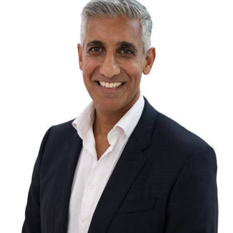
Nabil Lodey
Managing Director UK & Ireland, 1SpatialNabil Lodey
Managing Director UK & Ireland, 1SpatialNabil joined 1Spatial in 2024 as Managing Director UK & Ireland. He has extensive experience in the geospatial data sector having been CEO of another geospatial software & services company where oversaw a period of significant transformation and growth leading to a successful exit to private equity.
With a degree in Economics from Queen Mary College, University of London, Nabil started his career in the Royal Navy, with appointments at sea as well as joint operations in Iraq and Afghanistan. He was also seconded to the US Navy 5th Fleet in Bahrain and the United Nations in Georgia.
On leaving the military in 2007, Nabil practiced as a Barrister in Paris representing entrepreneurs, multinationals and Governments in International Arbitration Tribunals, before spending a year at London Business School as a Sloan Fellow studying for a MSc in Strategy & Leadership. Following a hugely rewarding role at the London 2012 Olympic Games, Nabil worked for corporates such as Lockheed Martin and KBR in business development & commercial roles.
Nabil has a passion for driving growth in tech businesses, primarily in the data sector and, since 2016, has held CEO roles in tech SMEs as well as co-founding two digital start-ups.
Connect with our FME Certified experts at the events, ready to tackle your toughest challenges!
Adrian Porter, Managing Consultant at 1Spatial
FME Certified Trainer since: 2013
Started using FME in: 2000
Profile: Adrian is a Managing Consultant in 1Spatial’s consultancy team in the UK. He’s been delivering GIS focussed training since the early 2000s and been a Certified FME Trainer since 2013. He’s delivered courses since this time in the UK, Australia and New Zealand. Adrian specialises in 1Spatial technology and FME and has applied his expertise across our regions, including when he spent time leading the Consultancy team in Sydney.
Certifications:
- Certified FME Professional
- Certified FME Trainer
- Certified FME Server Professional

Martyn Lufkin, Principal Consultant at 1Spatial
Started using FME in: 2010
Profile: Having had over 20 years within the GIS data industry, I have acquired over 13 years of experience using both FME Desktop and Server as a main software solution for ETL and processing tasks, involving both spatial and non-spatial data. I have presented at several FME World Tours over the past 10 years and enjoy using FME to solve a varying range of data problems.
Certifications:
- Certified FME Professional
- Certified FME Server Professional
- Certified Trainer

Ian Fletcher, Senior FME Consultant at 1Spatial
Started using FME in: 2016
Profile: I spent the first eight years of my career working in the oil and gas industry as an exploration geologist and product manager. I used FME products every day to manage a huge library of open source, and proprietary databases and products. Since joining 1Spatial in March 2020, I have been working on a number of client projects where FME products for an integral part of their data processing workflows.
Certifications:
- Certified FME Professional
- Certified FME Trainer

Tour Details & Location
Location: Edinburgh
Date: September 11th, 2025
Time: 9:00 AM – 4:00 PM
Venue: Edinburgh Marriott Hotel Holyrood,
81 Holyrood Rd, Edinburgh EH8 8AU
Location: London
Date: September 23rd, 2025
Time: 9:00 AM – 4:00 PM
Venue: 113 Chancery Lane,
London WC2A 1PL
Register Now


