

How to Make Subsurface Information Shareable Using GeoIM + Q-FAIR
PART TWO
Collaboration Through Subsurface Information Sharing: Why It’s Becoming Essential for Infrastructure Success
This article forms Part 2 of a three‑part series written by Matt White, Senior Business Development Manager at 1Spatial, exploring how organisations can turn the intent to share subsurface information into something practical and repeatable (read part one).
In the first article, we looked at why subsurface information sharing matters and why the industry is under increasing pressure to address long‑standing challenges around underground risk. The next question is more practical: how do organisations make subsurface information shareable across projects, teams, and systems?
From Fragmented Data to Shared Insight: The Role of GeoIM and FAIR in Subsurface Information Sharing
Turning fragmented data into a single source of truth requires more than goodwill. It requires a structured, interoperable approach. This is where Geospatial Information Management (GeoIM) and FAIR data principles take play.
The Challenge: Many Data Owners, Many Formats
Subsurface information rarely lives in one place. Utilities, transport agencies, local authorities, and contractors each hold their own data. This can be in formats such as CAD, GIS, PAS 128 outputs, AGS borehole logs, as‑built records, or bespoke schemas. This fragmentation makes it difficult for teams to form a reliable view of the ground.
GeoIM + FAIR: Turning Data into a Shared Asset
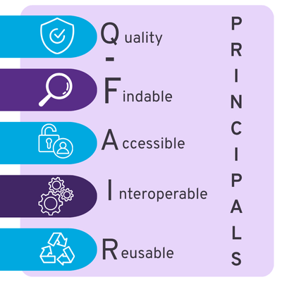
GeoIM applies the FAIR principles (Findable, Accessible, Interoperable, Reusable) to geospatial information. It creates the conditions for data to be shared, integrated, trusted, and reused across an entire project lifecycle.
This is what it looks like in practice:
1. Quality Subsurface data must possess the correct characteristics, accuracy, and reliability necessary for its intended real-world applications.
2. Findable Data stored consistently, with clear metadata, enables teams to locate and interpret information quickly.
3. Accessible Authorised users can securely access subsurface information without repeated requests or manual merging of datasets.
4. Interoperable Using shared industry models (such as the OGC MUDDI model) ensures data from multiple organisations and formats can work together seamlessly.
5. Reusable Quality controls, validation rules, and governance make data suitable for long‑term use, feeding into digital twins and future infrastructure planning.
How Different Stakeholders Benefit
- Design Engineers: Gain early access to reliable utility and ground data, reducing costly surprises.
- Geotechnical Specialists: Receive consolidated data they can trust.
- Contractors: Keeping programmes on track.
- Asset Owners: Benefit from reduced data request overheads.
The Result: Better Outcomes at Every Stage
From design through construction and into operation, GeoIM enables clearer decision‑making. It’s the foundation for consistent, industry‑wide collaboration on subsurface information.
Read the last article: Real examples, including NUAR and the FPS Piling Map, plus the strategic future of subsurface data in the UK.
Article Written by
Matt White, Senior Business Development Manger, 1Spatial

Get In Touch!
How do you see initiatives like NUAR transforming the way we build and maintain infrastructure? Contact us to explore collaboration opportunities.
Contact us