

National Trust

Enabling National Trust to monitor and report progress towards wildlife habitat target
VertiGIS Studio provides lifecycle management tool for demonstrating charity’s impact on UK nature
“VertiGIS Studio enables us to capture our exact progress towards delivering 25,000 hectares of newly created or restored priority wildlife habitats by 2025. National Trust staff at all levels love it because it tells us if we are on target and enables easy, accurate and up to date reporting. We have a well-established relationship with 1Spatial who have used their in-depth understanding of our organisation and its drivers to support our migration to VertiGIS STUDIO.”
Ian Dawes, GIS Product Manager, National Trust.
Benefits
- Enables National Trust to demonstrate its impact in improving the state of nature in the UK.
- Delivers evidence to show progress against strategic KPI that can be audited and verified.
- Ensures progress is measured against the appropriate target and avoids duplicate reporting.
- Improves efficiency by empowering staff on-the-ground to capture information, enabling central teams to focus on delivering projects requiring their specialist technical skills.
- Provides a low code, intuitive foundation for dashboard reporting that does not require a virtual private network (VPN).
To safeguard nature for the future, the National Trust is creating new, or restoring, priority woodland, wetland, meadows, orchards and habitats.
Background
The National Trust is Europe’s biggest conservation charity. In its 2020-2025 strategy, 'For everyone, for ever', the organisation sets out how it will achieve its 21st-century ambitions to help in the fight against climate change and safeguard nature for the future.
To reverse the decline in wildlife on land in its care, the National Trust is committed to delivering 25,000 hectares of newly created or restored priority wildlife habitats by 2025.
Challenge
Monitoring progress against this strategic KPI for nature is important for transparent reporting and demonstrating the charity’s impact, internally and to external stakeholders. However, managing the data was challenging due to the size of the area involved.
Solution
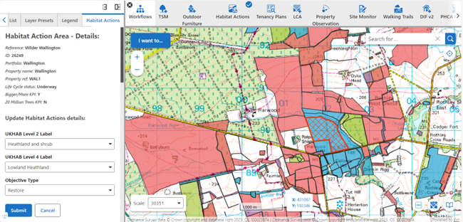
The National Trust is using VertiGIS Studio technology to configure its ArcGIS platform with a customised workflow to record information for managing this key corporate KPI.
Polygons are created by clicking on the map, the base for which is Ordnance Survey 1: 25,000 scale colour raster data with the option of zooming in to OS MasterMap for a more detailed view. Users then select other attributes about the land, including habitat type, relevant KPI and tenancy. The workflow legend is customised to display National Trust’s configurations: Identification of new habitats; creation and restoration of habitats; and management of completed habitats.
“It’s basically a lifecycle management polygon tool", explains Ian Dawes, GIS Product Manager, National Trust. “The first stage is identifying potential new habitats. Once plans are in place, budget is allocated and our spade is in the ground, the work on the polygon is marked as underway. Completed habitats are those where we’ve finished the work to create them rather than those that are now established because, of course, that takes time.”
“Our mantra is the data should be entered by the people as close to the property as possible as they know what’s happening on the ground. The platform is very user friendly and the idea is that people have the skills to enter their own data at the time of planning, whether that’s the project team or property-based staff as part of the estate management processes.”
“Areas are only identified as contributing to the KPI once marked as underway and, once classified to one KPI, cannot then be credited to another,” says Ian. “To allow for things like tracks and clearings, users can also define whether it is the whole of the polygon or just part of it that helps meet the target.”
“Once you hit submit, the polygon is updated, audited and then goes into the overnight feed for our nature dashboard. Various auditing processes, including some that are automated, are employed for checking the lifecycle status. The nature dashboard is used for our corporate reporting and in particular by our regional Nature Conservation Advisors who are responsible for checking progress against their allocated target. Selecting a region will show the updated target as it stands that evening. The dashboard also enables people to drill down to individual property level so they can see, and report on, their exact progress against the KPI.”
“Currently we are using VertiGIS as a customised lifecycle management tool for input-based KPIs. Our future plans include using the tool for working with partners, moving towards using remote sensing satellite data, and examining ways to record the quality and extent of land to further demonstrate our impact.”
In addition, the organisation took the opportunity to migrate from GeoCortex Essentials to VertiGIS Studio making it one of the first to move to the new framework. Distributed and supported by 1Spatial, with whom National Trust has a well-established working relationship, VertiGIS Studio bridges the gap between the basic functionality of ArcGIS and the need to employ developers to deliver more advanced options.
More than 2000 National Trust staff currently use this low code, intuitive suite of products that is customised to meet their requirements.
eNewsletter
Stay up to date with all the latest 1Spatial news and events through our eNewsletter
Register now