Ensuring supply chain data is complete, correct, and quality assured
How to ensure data that is collected and collated by multiple surveys, surveyors and methods is complete, correct, and quality assured
As we move through the Covid-19 crisis, much talk has been focusing on how we "build back stronger, build back better, and greener, but also faster.” The pandemic has taught us the cost of delay; however, questions are still raised as to our efficiency in the UK. For example, in 2018 we built 2.25 homes per 1000 people while Germany managed 3.6, the Netherlands 3.8 and France 6.8.
We know that time is money and there is recognition within government that the “newt-counting delays in our system are a massive drag on the productivity and prosperity of this country”, however habitat disturbance and destruction is a vital reminder that we cannot launch into a full-scale and rapid build, build, build approach without first considering what we are going to build, where we will build it, and what the impact of building it is. That’s why we have laws and a planning process that we must follow.
Conventions, Laws, Policies and Frameworks
Incorporated into the overall planning and development process are a load of wide-ranging international conventions (there are about 8 of these, including the Ramsar Convention on Wetlands of International Importance and the Convention on Biological Diversity, which is one of the 3 Conventions arising from the 1992 Rio Earth Summit), directives that come to us originally from the EU and are implemented via UK laws (The Birds Directive, The Habitats Directive, The Environmental Impact Assessment Directive, The Water Framework Directive).
Then there are additional local laws (a long list that includes, among others, the Town and Country Planning Act, the Wildlife and Countryside Act, the Natural Environment and Rural Communities Act, the Conservation of Habitats and Species Regulations, the Protection of Badgers Act, the Wild Mammals (Protection) Act).
Finally, there are national planning policies and frameworks, “standing advice” from regulatory authorities, and a raft of other guidance, especially when it comes to aspects of the natural environment and wildlife. These all, collectively, form the legislative framework governing how the environment, its ecosystems, and the plants and animals that already live where a development is proposed are treated and protected.
Impact Assessments and Standards
For large development projects, or those that might have a significant impact on the environment because of their nature, size, or location, an Environmental Impact Assessment (EIA) usually needs to be undertaken so that the planning process can assess the potential harm the development may cause. The current National Planning Policy Framework asks that these assessments, submitted usually in an Environmental Statement, follow a “mitigation hierarchy” that focuses on environmental impact "Avoidance, Mitigation, Compensation, and Enhancement". Development projects that require an EIA usually need to incorporate more specific Ecological Impact Assessments. These provide the evidence that is used to inform decision-making, both within the planning process and also regarding how a development project proceeds.
High-quality ecological information, which usually begins life as ecological survey data, is critically important for demonstrating a development's compliance with the rules, laws, and obligations regarding the project’s ecological impact. But what about data standards? Step up British Standard "BS42020:2013 Biodiversity: Code of Practice for Planning and Development". This is the standard that’s been developed to ensure that sufficient and appropriate ecological information is captured and used in the planning process and for other regulatory approvals. But it doesn’t go so far as to set down specific data and data quality standards.
In all these scenarios, business rules can play an important role to give us the control we need, and consistency when analysing the data.
Data Management Challenges
Habitat, species, and other ecological surveys create the evidence base by producing survey data. Potentially lots of data. Regular and ongoing monitoring of the environmental and ecological impacts of a development as it progresses also produces lots of data. As part of the mitigation hierarchy, a “biodiversity net gain” may also be expected as an eventual outcome of a development project. So, more data accumulates. Any comparisons that might be needed with pre-development “baseline” observations are usually data-driven comparisons which can further add data to the evidence base. Basically, a lot of data can accumulate.
The world of environmental and ecological surveys has surprisingly few prescribed common standards for recording, processing, checking, assuring, and then publishing the data captured by these ecological surveys. Add to the mix additional problems arising from different surveyors collecting data in different ways and it can become difficult to organise, structure, and compare data captured across a large project, particularly one with a large and hierarchical supply chain of many surveyors passing their data onwards and upwards.
The reliability of data therefore becomes questionable. The real challenge is how to ensure data collected and collated disparately and inconsistently from multiple surveys, by multiple surveyors, via multiple methods, is complete, correct and of known and assured quality. Business rules can help us here to measure this, consistently. They are even more useful and have a bigger positive impact when they can be applied in an automated solution, to shorten the time, effort and cost it takes to perform these tasks.
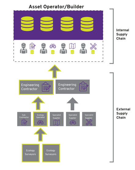
It’s not always obvious on a large development project, but there is often a real need to deliver better data to the next successive recipient up the supply chain. If survey data is incomplete or of questionable quality, it cannot really be trusted by those who receive it next, and ultimately rely on it to make and evidence decisions. Those collecting and submitting data along the supply chain may be unaware of any problems until the data is checked and collated higher up the project chain. When checked, which might not even happen for some considerable time, if incomplete or poor quality data is identified, it often results in a return journey back down the project chain with a request for re-survey and re-submission. This often comes with an extra cost for the extra effort.
This image is one example of how ecology survey data is collected and collated as part of a large supply chain.
In a country concerned about the historic and ongoing depletion of nature, it is important that we have the laws and statutory obligations that require the kind of evidence that comes from survey data, and that we don’t rush head-long into large infrastructure projects that could further deplete biodiversity, species abundance, and their habitats. If we really want to build back stronger, build back better, build back greener, and build a more beautiful Britain faster, then we must consider delivering better survey data throughout these projects and at every stage from planning and development to building and operating. Rules-based software techniques have a potentially large role to play in the delivery of ecological and environmental survey data by enabling fast and reliable automated solutions specifically in support of this. Such solutions will enable us to trust the data that is used in evidence-based decision making.
Find out more
For more information on how 1Spatial’s Ecology Solution helps organisations with supply chain data quality issues please get in touch.
Author - John Hartshorn - 1Spatial
On Demand Webinar
You can also download our recent Supply Chain webinars on demand to learn more.
Watch now