

Improving our environment based on natural capital asset datasets
Improving our environment based on natural capital asset datasets and spatial data infrastructures
Author: Matthew White, 1Spatial
Digital asset registers
In a previous blog I talked about how the design, implementation and management of digital asset registers are a stepping stone towards digital twin adoption for the built environment. Digital asset registers are also the stepping stone towards digital twins for the natural environment.
As stated by the Government Digital Service (GDS), registers provide structured datasets of government information to help organisations and individuals build services. Services, for example digital twins using registers, can reduce the time and cost of sourcing data from across government, ensure data received is ready to use with no need for data cleansing, and give confidence that services are using the most up to date data. As per GDS guidance, each register only contains data on a specific subject. It is kept up to date by a subject matter expert from the relevant government organisation and shares a common API that supports JSON and CSV.
Registers need to be created from data, either sourced and/or mapped. There are numerous examples of digital asset registers being developed using data for the built environment. For example, the Digital National Asset Register (DNAR) and National Underground Asset Register (NUAR).
Developing natural capital asset registers
In 2019 the UK Government set out a ‘Green Future: Our 25 Year Plan to Improve the Environment'. This plan sets out what we will do to improve the environment, within a generation. There is a policy to use and manage land sustainably by designing and delivering a new environmental land management system. The UK Government has since consulted on a new Environmental Land Management Scheme (ELMS) and setup tests and trials. This scheme is the cornerstone of the government’s new agricultural policy. It will provide a way of achieving the goals of the 25 Year Environment Plan and commitment to net zero emissions by 2050, while supporting our rural economy.
Benefits from our natural environment are affected by the quantity, quality or location of the underpinning assets and people’s ability to access them. For example, for outdoor recreation, the location of recreation areas such as woodlands in proximity to people is a key determinant of how much they will be used and therefore the benefits derived from them.
There is a growing need to develop registers of natural capital assets and services in an area to develop a Land Management Plan. As stated by the Natural Capital Committee, an asset register is an inventory of the natural assets in an area, and their condition. For example, woodland could be defined by its type, its area, quality, population, and distribution. The committee outlines that asset registers should include:
- The boundary, extent, and type of land cover (woodland, farmland, heathland, etc),
- Significant land managers in the area (e.g. farmers, water companies),
- Major land use types (e.g. residential, transport, agricultural, forestry, recreational, industrial). Equivalent systems will need to be developed for marine areas),
- Who owns which assets,
- The ecosystem services that it provides and its state/condition as measured by quantity (extent, volume, or amount), quality and location (spatial) metrics,
- What the asset is being managed for (e.g. wildlife, food, timber, recreation).
Natural capital asset registers and Land Management Plans need asset datasets. The ELMS tests and trials have reported that asset data availability, accessibility, and consistency vary dramatically, and that local datasets are of particularly poor quality.
The Natural England County and City Natural Capital Atlas project, completed in Spring 2020, aimed to assess the extent and state of Natural Capital in counties and metropolitan regions across England. The project followed on from the National Natural Capital Atlas, which mapped natural capital across the whole of England. Both sets of atlases map out the Natural Capital Indicators to show how much, how good and where England's ecosystem assets are, and the benefits they are providing to people. The atlases use the best available and nationally consistent data sets and highlight data gaps.
Representing natural capital assets as geospatial data
Geospatial data represents many of our national physical natural capital assets, approximately 80% of all data has a location. Spatial Data Infrastructures (SDI) and the geospatial data that they represent are critical to improving our environment, by helping produce and maintain registers of natural capital assets, natural capital plans and the adoption of digital twins for the natural environment. There is a need to continually source and/or map natural capital assets and their quality for a given area, bringing data together as registers for developing, implementing, and evaluating Land Management Plans.
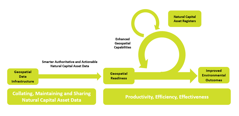
The below diagram represents how our tools and expertise, ensure that your data is geospatially ready:
Authoritative natural capital asset datasets are currently available to help determine registers. Many of these sources are represented as national geospatial data and from government organisations as described in the Natural England Atlases, including Environment Agency, Joint Nature Conservation Committee, Defra, Forestry Commission, Natural England, Office for National Statistics and Ordnance Survey Great Britain. However, these datasets are not always FAIR (Findable, Accessible, Interoperable and Re-usable) and integrated
We support authoritative natural capital asset datasets
We support government organisations to manage authoritative natural capital asset datasets based upon SDIs for determining future natural capital asset registers.
Rural Payments Agency (RPA) in England supports £3 billion of payments to farmers and landowners each year. RPA’s SDI consists of critical geospatial natural capital asset datasets that are used to calculate payments. This includes 2.6 million land parcel (boundary and extent) asset records, 3.5 million land cover asset records and hedgerows asset records. We enable the Rural Payments Agency to govern and publish these authoritative asset datasets using our Location Master Data Management (LMDM) approach and tools, for example 1Integrate.
Natural Resources Wales are providing firm foundations for Wales to deliver its ambitions set out in the Environment Act and Well-being of Future Generations Act. Natural Resources Wales’ SDI consists of authoritative geospatial natural capital asset datasets that form an evidence base for assessing the extent to which sustainable management of natural resources is being achieved, recommendations for progress and the natural resources registers showing pressures, impacts and opportunities for action. Tools from 1Spatial enable Natural Resources Wales to achieve their geospatial vision of an organisation empowered through the use of geospatial technology and information. The use of Geocortex allows Natural Resources Wales to share, visualise and analyse spatial data in meaningful ways. The use of FME as their core extract transform and load tool allows them to carry out complex data transformations making day to day and future SDI activities achievable.
The Department of Agriculture, Environment and Rural Affairs (DAERA) in Northern Ireland supports £millions of payments to farmers and landowners each year. Like RPA, DAERA’s SDI consists of natural capital asset datasets, including approximately 700 thousand land parcel asset records. We enable DAERA to maintain their authoritative record of land parcels for their Land Parcel Identification System using our geospatial tools.
Our approach and tools
We provide solutions that can manage authoritative natural capital asset datasets for determining natural capital asset registers. The LMDM approach we take and tools we offer follows learning by doing, overcoming by sharing and succeeding together through data collaboration, data automation, data transformation, data validation and data visualisation principles.
- Data Collaboration – working with employees and stakeholders internally and externally to share asset data management responsibilities and connect authoritative and actionable asset data at local, regional, and national scales using 1Data Gateway and our Location Master Data Management
- Data Automation – operationalising automated data workflows to manage and share authoritative and actionable asset data at local, regional, and national scales using 1Data Gateway, 1Integrate, FME and Geocortex.
- Data Transformation – making asset data fit for purpose by transferring and transforming data between data source(s) and target interface(s) using Safe Software’s FME and 1Integrate.
- Data Validation – ensuring asset data is both correct and complete using 1Integrate.
- Data Visualisation – making authoritative and actionable asset information accessible using VertiGIS’s Geocortex.
Find out more
If you would like to find out more about how we work with government organisations to connect and unlock the value of a location, by managing authoritative natural capital asset datasets, using SDIs for determining natural capital asset registers, please get in touch.