

Future Benefits of 3D
We recently hosted a series of webinars, discussing our perspective on true 3D data. During the first webinar we asked the audience when they plan to adopt 3D data into their organisation, and almost 80% had short term plans to use 3D data: Some in the next 6 months and some in the next 1-2 years. This got us thinking about the future possibilities of using true 3D data to benefit all and in turn wider society.
True 3D data
By true 3D data we mean structured spatial data in which the heights are not just a single number stored on each feature (e.g. height or depth attribute) but are stored on every vertex of a geometry and these geometries represent not just points, lines or polygons but also solids with a volume. 3D data can also be captured from or managed as LIDAR point clouds, photogrammetry from oblique aerial photography, terrain grids or terrain triangulations. Heights have always been tricky – we have rigorous ways to measure horizontal position but height is a bit harder for devices. And should assets be recorded using a height above sea level, or relative to ground level and if so, what’s the definition of the ground level?
Nevertheless, the benefits of considering heights and 3D are huge and some of the use cases we hear about or anticipate are listed below.
Do you have another vision for the future use of 3D data? If you are happy to share, we would love to hear it and discuss this further with you. Just get in touch with us at: innovation@1spatial.com
Flood Management
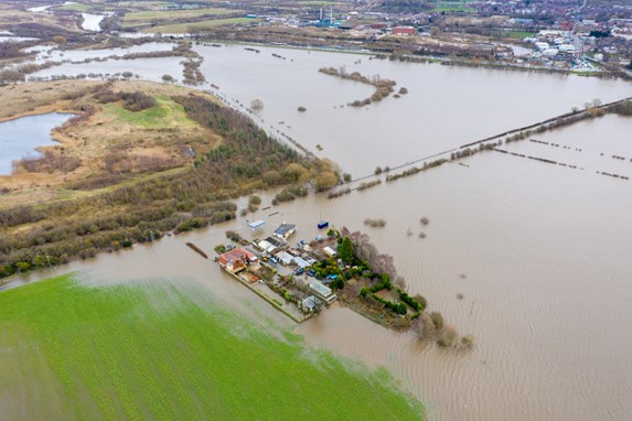
Traditionally, flood analysis is simply done by drawing a horizontal plane with the expected water depth, so anything under Xm altitude is flooded. Advanced analysis packages are more intelligent and consider surface permeability, gravity models and other factors. However, they tend not to consider the funnelling and damming effect of buildings within an urban environment. This can cause a peak localised flood level that many of the current packages cannot model. As the effect of flooding within large urban areas becomes more significant (as we saw in Germany in 2020 and in New York recently), the software will improve further to factor this in. High quality, topologically complete data will be essential to support this.
The image below is a good example of a less simple case.
Vegetation Encroachment for Utilities or Transport
Managing ever-growing vegetation is a key risk for transport or other industries. Trees are often captured as points or circles, with actual risk approximated based on other information such as height, age or species. For a rail network management this information is used to plan tree pruning to avoid train strikes. Having an accurate model of the tree is very useful. Trees grow on embankments at an angle and have different growth patterns. One approach is to use sensors on trains to capture point clouds which can give an indication of the current size of the tree. This information can be used to refine and enhance the model to provide a more accurate risk analysis. Without it, there are train, passenger and driver safety issues from tree strikes or the risk of wasting effort and money on pruning trees too frequently.
A simplified approximation of a tree from a circle and height

Reality

This example shows how combining sensors with simper solid models could enhance the analysis of vegetation growth to find the optimal balance between risk and cost.
Digital Twins, Smart Cities and Planning
We have spoken in a previous blog about smart cities and the scenarios to test out here are exciting, especially when conflating different sources together to create a high-fidelity view (or Digital Twin) of the world. Introducing a 3D element to this takes the fidelity up a level. As a result, we are looking to help our customers ask questions around;
- Solar panel placement analysis: Estimate capacity of a building based on slope and direction of rooves vs shadow from surrounding buildings
- Building efficiency: Approximate heat retention based on building age, 3D shape and sun exposure
- NMA and intelligent taxation: Predict correct tax based on internal apartment size or sea view
- Facilities management: Planning and costing pre-build or ongoing post-build maintenance
- Room volume calculation
- Ensure 3D model does not self-overlap
- Ensuring space to rotate wheelchairs
- Emergency response: Data sharing to get a full ‘smart city view’ i.e. ensure predictions for floods will be more accurate with data from highways / utilities / NMAs and environment agencies and other important stakeholders and data providers.
Example
The Danish Agency for Data and Efficiency (SDFE) are using 1Integrate 3D to build a digital twin of Denmark. The national 3D city model will be used by a number of government departments to handle, for example, climate change, disaster mitigation and tax calculations.
SDFE is investigating the potential applications and technical prerequisites for establishing a country wide 3D model of Denmark on the basis of existing and geographical data. SDFE has started a pilot project together with the municipality of Aarhus, which focuses on relevant use cases for 3D modelling in Danish municipalities.
Following the trial there is a proposed plan to establish a national 3D city model. SDFE would be the guarantor that the model is updated and reliable, and the data distributed and made available to all government departments. The automated process ensures that the data is both current, but also validated and corrected to ensure it is of good quality, and that all users can have confidence in the data’s use. 1Integrate 3D is being used in the prototype of the management system.
As well as the national 3D city model it is proposed to enable a municipality to incorporate more detailed 3D data into a joint model, provided the external data passes the data quality specification. An example more detailed data could be a scan of a historic building of interest.
Get in touch
We are seeing an increasing need for 3D data across multiple sectors and organisations. If you would like to learn more about how 1Spatial can help with your 3D data. Get in touch to speak to one of our experts.
Get in touch