Transforming infrastructure projects with information management
This article is a duplicate of a guest post published on GEO Business. For the original, please visit Navigating Data Integration and Quality for Infrastructure Projects: Case Study - GEO BUSINESS
In this article, Matthew White, Head of Built Environment at 1Spatial, writes about navigating data integration and quality for infrastructure projects, presenting a case study on the Environment Agency’s journey.

There is significant emphasis on information management within infrastructure projects across the public sector, private sector, and academia. Many organisations, including the Institute of Asset Management and the International Organisation for Standardization, are dedicated to enhancing information management for infrastructure by setting direction, policy, guidance, standards, and best practices.
These organisations are proactively prioritising collaboration and have already established collaborative relationships, notably buildingSMART International and the Open Geospatial Consortium joint initiative, to develop a roadmap to achieve consistent, integrated, and seamless information flow across BIM and GIS domains.
Another example is the UK Government’s Transforming Infrastructure Performance Information Management Initiative, led by the Construction Leadership Council and supported by nima. If you’re not familiar with this initiative, I recommend looking into it.
Information management is crucial for transforming infrastructure performance
Infrastructure information serves as the foundation and the glue in frameworks and initiatives, whether organisational or project-level, enabling business operations including measuring, modelling, monitoring, and managing infrastructure.
A consistent, integrated, and seamless information flow, encompassing both geospatial and non-geospatial data, is essential to the delivery of infrastructure projects on time and on budget. This information flow supports project and program management, finance and commercial activities, organisational planning and response, risk management, audit, and compliance.
Information management also supports digital transformation and the adoption of new technologies in infrastructure operations.
Effective information management delivers direct positive impacts both internally and externally, boosting productivity throughout the infrastructure lifecycle. This is why information management is receiving so much attention.
The Information management challenge – focus on data integration and quality
The gap between the need for information and its effective management is often significant. Data has become larger, more complex, siloed, with a fast-moving operating environment that makes data sharing even more critical.
The Project 13 Data and Digital Benchmarking report for 2023 highlighted challenges related to data integration. The survey revealed that a lack of focus on data integration leads to duplication and information loss at system boundaries. These challenges are often linked to the diversity of sources, data consistency, data volume, and real-time integration.
Additionally, the report underscored issues with data quality, noting that poor data quality hampers individuals’ ability to make effective data-driven decisions. Data quality challenges are typically associated with accuracy, completeness, reliability, and timeliness of data.
Geospatial Information Management
With over 60% of infrastructure information being explicitly geospatial, Geospatial Information Management (GeoIM) can significantly enhance infrastructure performance.
- GeoIM ensures seamless integration of relevant infrastructure data from various sources, providing a holistic view that improves decision-making throughout the infrastructure lifecycle.
- High-quality infrastructure data is essential for effective GeoIM. By maintaining data accuracy, consistency, and completeness, infrastructure owners can rely on this information for their operations.
- GeoIM adds spatial context to infrastructure data. Whether mapping utility networks, modelling flood risks, or analysing transportation routes, understanding geospatial relationships enhances asset management.
- Infrastructure owners can optimise maintenance schedules, monitor performance, and predict failures using GeoIM. For instance, real-time tracking of fleet vehicles or monitoring the condition of bridges becomes more efficient.
- GeoIM contributes to building resilient infrastructure. By analysing geospatial data, infrastructure owners can identify vulnerabilities, plan for disaster response, and adapt to climate change impacts.
- GeoIM fosters collaboration among stakeholders. Whether sharing infrastructure data with emergency services during a crisis or collaborating on urban planning, having the right information at the right time is crucial.
Environment Agency transforming infrastructure performance including GeoIM
The Environment Agency is responsible for protecting and enhancing the environment across England. Flood and Coastal Risk Management accounts for about half of the Agency’s annual expenditure, focusing on building, maintaining, and operating flood defences, as well as providing effective flood warnings to communities. Data about its extensive flood and coastal defence infrastructure, which are crucial components of the national infrastructure, is as important as the physical infrastructure itself. Therefore, robust information management is essential to reduce flood risk, increase efficiency, enhance infrastructure utilisation, and boost resilience.
The Environment Agency is transforming its infrastructure performance through smarter information management, including GeoIM. Their approach has been recognised as industry-leading, earning them the Asset Management Project of the Year award last year.
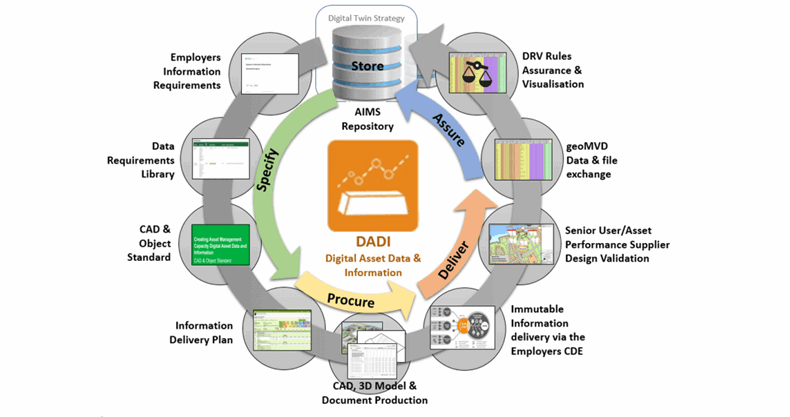
They have developed an information management framework, including GeoIM, designed to provide reliable and trustworthy information, even when produced by external sources. This framework begins with specifying clear information requirements, both geospatial and non-geospatial, from internal and external sources. It then involves procuring, delivering, assuring, and storing data for use by various systems, including GIS, analytics, and asset management.
Information management activities implement this framework, with data integration being crucial for transitioning data from delivery to storage through assurance. Data quality is essential for the assurance process (checking data). The Environment Agency has established a robust information management framework where data integration and quality are fundamental to its successful implementation.
Environment Agency data integration and quality
This diagram represents the Environment Agency’s information management activities, driven by three R’s: requirements, rules, and reporting. A process has been designed to ensure that data and information about infrastructure projects meet the Environment Agency’s requirements, are managed in a structured way, and are handed over to operations in a timely manner.
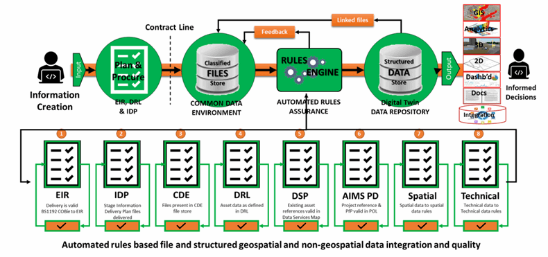
The process is automated for:
- Extracting and integrating information from the Environment Agency’s common data environment using Safe Software’s FME tool.
- Checking the quality of information against the Environment Agency’s requirements using rules, and conformance reporting using 1Spatial’s 1Integrate rules engine.
- Loading conformant information into a structured data repository using FME.
This process ensures that consistent, high-quality information is available to the Environment Agency’s users and stakeholders for business operations and digitalization sooner.
Data integration activities are supported by standards that encompass both geospatial and non-geospatial infrastructure data. For example, geoCOBie extends the Construction Operations Building Information Exchange non-proprietary file format to include geospatial data as part of the same data integration activities.
Data quality activities using 1Integrate are enabled by collaborative rules. A wide range of sources must be checked against before data can be stored, and rules provide the mechanism for these checks.
The Environment Agency’s information management activities are being leveraged by different infrastructure projects, including the Bridgwater tidal barrier project, protecting Bridgwater and the surrounding communities from flooding.
Karen Alford is spearheading the Environment Agency’s digital and data standards approach for managing information on their infrastructure projects. I asked Karen to share her thoughts on the importance of data integration and quality to the Environment Agency:
‘Getting the right data quality has always been a challenge for a large infrastructure organisation such as the Environment Agency. Most of the geospatial and non-geospatial data we use is produced by a third party.
Addressing data standards and quality requirements as an independent entity supported by a responsive governance process is bringing value to how we use data within our business.
Building an independent rules service to integrate and assure newly created data against our requirements before formal acceptance brings a step change to largely manual processes. Building tools to automate data into our asset management systems will improve data quality and completeness significantly and improve productivity.’
Karen Alford - Digital and Data Standards Manager, Environment Agency
How can 1Spatial help you?
Ensuring accurate data and information for infrastructure projects is a challenge for any large organisation and is critical for effectively operating and maintaining infrastructure within ever-tightening budgets. 1Spatial’s GeoIM experts can collaborate with you to understand your immediate needs. Their 1Integrate technology, as a commercial off-the-shelf (COTS) solution, offers a scalable option that can be easily configured to your business rules using generative AI models.
Contact us